



The proposed railway corridor could cut the detour via Miraj, serve industrial hubs along NH-48 and connect North Karnataka with western Maharashtra. The project now awaits further technical clearances and decisions on funding.
BELAGAVI: The proposed Belagavi–Nippani–Kolhapur direct railway line has completed its reported field-survey phase, bringing renewed attention to a long-pending demand for better rail connectivity between North Karnataka and western Maharashtra.
The Preliminary Engineering-cum-Traffic (PET) survey, involving drone mapping, GPS measurements and ground-level verification, has examined a possible alignment through the Sankeshwar, Nippani and Kagal regions. The next major steps include finalising the project report, obtaining the necessary railway approvals and securing funding.

The proposed line is intended to reduce the circuitous rail journey via Miraj and improve passenger and freight connectivity across the Karnataka–Maharashtra border.
Here is a breakdown of the proposed route, stations, engineering considerations and the steps that remain before the project can move towards construction.
Drone and GPS survey completed
Pune-based Monarch Surveyors & Engineering Consultants Ltd. reportedly carried out the PET survey commissioned by South Western Railway, Hubballi, with a reported survey allocation of ₹55 lakh.
The survey used drones, GPS mapping and ground-level markings to study terrain, land contours, water crossings and other engineering requirements along the proposed corridor.
The completion of fieldwork, however, does not mean the railway line has received final approval or that construction is ready to begin.
Proposed railway line along the NH-48 corridor
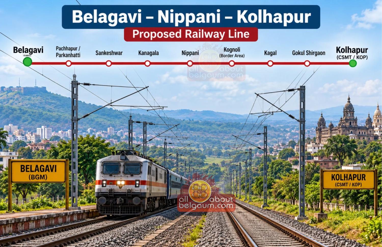
The proposed route would connect Belagavi with Kolhapur through the Sankeshwar, Kanagala, Nippani and Kagal belt, broadly following the Pune–Bengaluru National Highway (NH-48) corridor.
The surveyed alignment is described as a double-track, electrified broad-gauge railway designed for speeds of up to 160 km/h.
The route would use the existing Belagavi–Miraj railway line for its initial stretch before branching towards the northwest. This would avoid the need to construct an entirely new railway corridor out of Belagavi city.
The final alignment and technical specifications remain subject to approval.
Proposed stations and railway junctions
The survey document identifies the following existing stations, proposed stops and possible operational points. The final station list will depend on the approved DPR.
Belagavi Railway Station: The existing station would serve as the southern starting point for trains using the proposed corridor.
Pachhapur/Parkanhatti: These locations on the existing railway line have been examined as possible branching points for the new alignment. The final junction is yet to be confirmed.
Sankeshwar: A proposed passenger station intended to serve Sankeshwar, Hukkeri and surrounding agricultural and commercial areas.
Kanagala: The industrial area along NH-48 could be served by a station, industrial halt or freight facility, helping manufacturing and agro-processing units transport goods.
Nippani: One of the principal proposed stations on the route, Nippani could benefit from improved passenger connectivity and easier movement of goods linked to its tobacco, jaggery and textile trade.
Kognoli border area: A possible operational halt or crossing point near the Karnataka–Maharashtra border has been mentioned in the survey material. Its inclusion is not confirmed.
Kagal: The proposed station could serve passenger traffic and industries in the Kagal–Hatkanangale industrial belt in Maharashtra.
Gokul Shirgaon: The industrial and suburban area near Kolhapur has been identified as a possible operational stop or crossing location. Its final station status is yet to be established.
Chhatrapati Shahu Maharaj Terminus, Kolhapur: The existing Kolhapur railway terminal would form the northern end of the proposed corridor.
The above list is indicative, not an officially notified final station schedule. The exact station locations, junction arrangements and operational facilities require confirmation through the approved project plan.
Why does the railway line branch off at Pachhapur or Parkanhatti?
One of the key questions surrounding the proposal is why the line would not run directly from Belagavi city alongside NH-48.
The surveyed approach reportedly considers branching from Pachhapur or Parkanhatti on the existing Belagavi–Miraj line. The document identifies three main engineering and cost considerations.
Terrain and gradients: The Kakati–Bhutaramanahatti–Sutagatti belt has significant elevation changes. A railway designed for higher speeds and freight operations requires carefully controlled gradients and curves. Using the existing railway corridor to descend towards Pachhapur and Parkanhatti could help avoid expensive earthworks, deep cuttings and major structures through difficult terrain.
Urban development and defence land: The approaches north and west of Belagavi city include built-up areas, Cantonment and defence land, road infrastructure and industrial development. Acquiring a continuous corridor for a new double-track railway through these areas could be expensive and complicated.
Cost savings: The existing Belagavi–Miraj line is already doubled and electrified. Using this infrastructure for the initial stretch could reduce the need to acquire additional land and build parallel tracks from Belagavi.
The proposed alignment therefore seeks to balance engineering feasibility, operating requirements and construction costs rather than follow the highway corridor directly from the city.
How long will the proposed railway line be?
The survey material refers to more than one possible alignment length.
One option is described as an approximately 58-km direct link between the Nippani–Sankeshwar region and Kolhapur, while another considers an approximately 85-km route from Parkanhatti through Sankeshwar to Kolhapur.
The longer alignment reportedly includes a technical diversion of about 24 km to negotiate terrain and maintain suitable railway gradients and curves.
These figures represent alternative alignment descriptions in the supplied material. The final route length cannot be treated as confirmed until the Railway Board approves the alignment and the DPR establishes the definitive distance.
How will the line benefit Belagavi and surrounding regions?
If implemented, the railway line could offer several benefits to the region.
- Shorter rail journeys: A direct connection could reduce dependence on the existing circuitous route via Miraj for travel between Belagavi and Kolhapur.
- Better passenger connectivity: Residents of Sankeshwar, Nippani and adjoining areas could gain improved access to railway services, subject to the final station plan and train operations.
- Industrial freight movement: The Kanagala and Kagal industrial belts could benefit from better rail access for goods transport.
- Agricultural trade: Improved rail connectivity could support the movement of agricultural produce and goods associated with regional trading centres.
- Interstate connectivity: The line could strengthen rail links between North Karnataka and western Maharashtra.
- Future network integration: The proposed corridor could connect with the planned Dharwad–Kittur–Belagavi railway line, subject to the development and integration of both projects.
These are potential benefits; actual travel-time savings, train services and freight capacity will depend on the final design and operating plan.
What is the proposed funding model?
The supplied document refers to an earlier proposal for a 50:50 cost-sharing arrangement, with Karnataka expected to provide land free of cost and contribute 50% of the project cost within its jurisdiction.
The project has also reportedly been pitched for support under the Centre’s PM Gati Shakti framework.
However, the final project cost, the states’ financial commitments and the Centre’s funding arrangements have not been established in the material provided. The proposed funding model should not be interpreted as a sanctioned financial package.
What approvals are still pending?
Despite the reported completion of the field survey, several important milestones remain before construction can begin.
- Final project report: The feasibility findings and proposed alignment need to be consolidated into the relevant project documentation.
- Railway Board scrutiny: The alignment, engineering requirements, traffic potential and financial viability need to undergo the required technical evaluation.
- Funding approval: The project requires a confirmed financial arrangement and the necessary budgetary allocation.
- Land acquisition and clearances: Once the alignment and project are approved, the required land, statutory clearances and implementation arrangements would need to be addressed.
- Construction timeline: No confirmed construction commencement date or completion deadline is established in the supplied material.
The distinction is important: completion of a preliminary survey is a technical milestone, not the same as final project approval or a construction sanction.
A railway demand dating back to 1903
The demand for a direct railway connection through Nippani is described in the supplied document as dating back to 1903.
It also records a historic campaign in which residents of the Nippani region reportedly sent 31,000 postcards to the Central Government seeking railway connectivity.
The latest survey has renewed expectations among residents and trade bodies in the Belagavi–Nippani–Kolhapur region. The challenge now is to move the proposal beyond preliminary engineering studies and secure the approvals and funding required for implementation.
What happens next?
Completing the reported drone and GPS survey gives the proposed Belagavi–Nippani–Kolhapur railway line a clearer technical basis. But the project’s progress will ultimately depend on the final alignment, Railway Board scrutiny, funding commitments and formal approval.
For Belagavi and the surrounding border region, the key question is no longer only where the proposed railway line could run. It is when the proposal will receive the approvals and financial backing needed to move towards construction.